
HIKING TO WILLARD PEAK
August 2008 - 72 photos
August 2008 - 72 photos
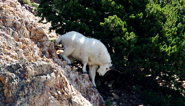
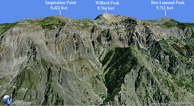
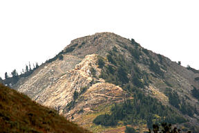
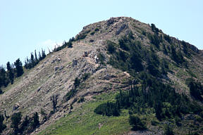
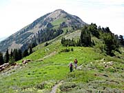
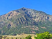
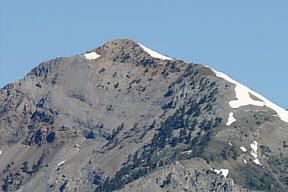
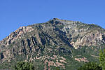
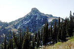
On August 12th of 2008, three of us, Judy Watson, Bill Joy and myself, hiked to Willard Peak from Willard Basin. Willard peak is 9,764 feet above sea level and is the highest peak in Weber County. We climbed 1,108 feet and walked 2.91 miles round trip. It was a beautiful day for a hike and again this year there were a lot of wild flowers. I took a large 500mm lens with me this time with the idea of getting good close-ups of the mountain goats, but it was a chore carrying it up the mountain. Some of the time I carried it in my backpack and sometimes in my hand, depending on the terrain. I doubt that I will climb many more mountains with it.

We were hoping to see some moose at Perry Reservoir as we were driving up, but there was someone on a motorcycle there and the moose were gone. We did find some moose farther on up the road a few miles. We also saw about 28 Mountain Goats on the cliffs below Willard Peak. We managed to take more than 350 photos between us and as usual it was a hard choice deciding what not to use. The three of us have top quality cameras with large telephoto lenses and we expected to see some Mountain Goats on this hike, which we did, but they were very high on the mountain side. Most of the goats we photographed were very far away, more than a thousand feet.
If you want to see more pictures of Mountain Goats, check out my 2005 and 2006 Ben Lomond hikes.
If you want to see more pictures of Mountain Goats, check out my 2005 and 2006 Ben Lomond hikes.
If you are interested in Mountain Goats, check out 2005 & 2006 Ben Lomond hikes
you can view our photos by clicking on any of the pictures here
or the 'View Photos' button
or the 'View Photos' button
CLICK for GPS map of our trek

For road map to Willard Basin , CLICK here
If you want to drive up to Willard Basin, I have included a couple of maps showing the way. I broke the map into two parts so that it can be printed. Take highway 91 east from Brigham City and get off at the exit for Mantua, (Man-ta-way), The road is marked in red on the map, but be advised, the road is a 4 wheel vehicle road only. After the first half it gets very rough. It takes more than an hour to travel it one way. Watch out for off road ATV's, as they travel this road a lot.
- 72 photos -
to look at these photos
click 'View Photos' button
Related Photos
Hiking to Ben Lomond, and Willard Peak
Ben Lomond, 2005
Ben Lomond, 2006
Ben Lomond, 2010
Ben Lomond, 2012
Ben Lomond, 1998
Ben Lomond, 2004
Ben Lomond Falls, 05

Willard Peak, 2003
Many of these photos were taken with my new Canon EOS 40D, 10.1 Megapixel SLR Camera and the Canon EFs 17-85mm IS wide angle to 5x zoom lens. I also used a Canon EF 500mm IS Telephoto for close ups, with the 1.4 extender added for 22.4x. Some of these photos were taken by Bill Joy with his Fujifilm Finepix s6000fd, wide angle to 10.7x optical zoom, and others by Judy with her Canon Digital Rebel XTi, using a Canon EFs 18-55mm Wide angle to 3x and an EF 75-300mm 10x zoom lens.
These photos are set to lower resolution and compressed 10:1 for faster loading. You are welcome to look at or download any of the photos. If you use them on any other webpage, please give credit and refer back to me.
[an error occurred while processing this directive]
Visitors on site now (
[an error occurred while processing this directive]
)
Total visits
[an error occurred while processing this directive]
If you want to drive up to Willard Basin, I have included a couple of maps showing the way. I broke the map into two parts so that it can be printed. Take highway 91 east from Brigham City and get off at the exit for Mantua, (Man-ta-way), The road is marked in red on the map, but be advised, the road is a 4 wheel vehicle road only. After the first half it gets very rough. It takes more than an hour to travel it one way. Watch out for off road ATV's, as they travel this road a lot.
- 72 photos -
to look at these photos
click 'View Photos' button
to look at these photos
click 'View Photos' button
Related Photos
Hiking to Ben Lomond, and Willard Peak
Ben Lomond, 2005
Ben Lomond, 2006
Ben Lomond, 2010
Ben Lomond, 2012
Ben Lomond, 1998
Ben Lomond, 2004
Ben Lomond Falls, 05
Willard Peak, 2003
Many of these photos were taken with my new Canon EOS 40D, 10.1 Megapixel SLR Camera and the Canon EFs 17-85mm IS wide angle to 5x zoom lens. I also used a Canon EF 500mm IS Telephoto for close ups, with the 1.4 extender added for 22.4x. Some of these photos were taken by Bill Joy with his Fujifilm Finepix s6000fd, wide angle to 10.7x optical zoom, and others by Judy with her Canon Digital Rebel XTi, using a Canon EFs 18-55mm Wide angle to 3x and an EF 75-300mm 10x zoom lens.
These photos are set to lower resolution and compressed 10:1 for faster loading. You are welcome to look at or download any of the photos. If you use them on any other webpage, please give credit and refer back to me.
[an error occurred while processing this directive]
Visitors on site now (
[an error occurred while processing this directive]
)
Total visits
[an error occurred while processing this directive]
Hiking to Ben Lomond, and Willard Peak
|
Ben Lomond, 2005
|
Ben Lomond, 2006
|
Ben Lomond, 2010
|
Ben Lomond, 2012
|
|
Ben Lomond, 1998
|
Ben Lomond, 2004
|
Ben Lomond Falls, 05
|
Willard Peak, 2003
|
Many of these photos were taken with my new Canon EOS 40D, 10.1 Megapixel SLR Camera and the Canon EFs 17-85mm IS wide angle to 5x zoom lens. I also used a Canon EF 500mm IS Telephoto for close ups, with the 1.4 extender added for 22.4x. Some of these photos were taken by Bill Joy with his Fujifilm Finepix s6000fd, wide angle to 10.7x optical zoom, and others by Judy with her Canon Digital Rebel XTi, using a Canon EFs 18-55mm Wide angle to 3x and an EF 75-300mm 10x zoom lens.
These photos are set to lower resolution and compressed 10:1 for faster loading. You are welcome to look at or download any of the photos. If you use them on any other webpage, please give credit and refer back to me.
These photos are set to lower resolution and compressed 10:1 for faster loading. You are welcome to look at or download any of the photos. If you use them on any other webpage, please give credit and refer back to me.