
HIKING TO BEN LOMOND
June 2012 - 54 photos
June 2012 - 54 photos
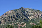
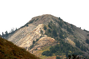
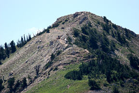
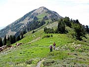
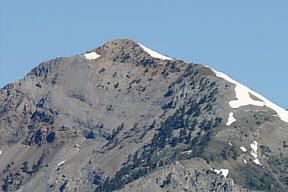
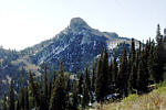
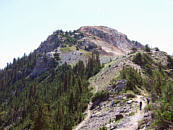
On June 22nd of 2012, we did another hike up to Ben Lomond going the easy way. Some people think hiking up from Willard Basin is not a real hike, but as an old guy, I can tell you that it was hike enough for me. My daughter Cheryl went with me, as well as our friends Marlene, and Don. We heard that it was going to be breezy, so decided that we had done enough bike riding in the wind and opted for a hike. As we were driving to Brigham City, the winds were blowing quite hard. We drove up through Mantua, taking the dirt track up to Willard Basin, a rough dirt road about 14 miles long. Going this way leaves only about 3 miles over to Ben Lomond to hike. Any other way the hike is 6 to 8 miles one way.

Someone that we knew told us that we wouldn't be able to get up to Willard Basin, as that high country was still snowed in. He said that some of his friends couldn't even get up there on ATV's. I had taken photos of the east side two days earlier and saw only a few small patches of snow, so I said lets give it a try. We did find a little snow, but didn't have to drive through any of it, although we did walk across a few small patches higher up. Snow was not a problem at all.
When we got up on top, the wind was blowing quite hard, and keeping hats on was a problem. Don didn't have tie down cords on his hat, but came up with a unique solution. tying it down with his bandana. Up on Ben Lomond Peak, we figured it was blowing at least 40 mph, with gusts higher than that. It was hard to keep our balance in the gusts.
On the day we did this hike, there were a number of wild fires about the state. Because of the winds, the smoke was saturating the air and made it difficult to get good photos.

We were hoping to see some wildlife, maybe deer, moose, and mountain goats, but didn't see much of anything until about half way through the hike, where we found signs that goats had been sleeping alongside the trail. Then we noticed that they were all over the hillside down below us. They were really hard to see this time, and so far off that it was hard to get good photos. I am glad that I have a good camera, and was able to get a few pictures, but they were taken at extreme telephoto zoom.
My GPS showed the hike from Willard Basin over to Ben Lomond Peak to be 3.2 miles. Most maps show Ben Lomond at 9,712 feet above sea level, but my GPS showed only 9700 feet. Not sure where the error is. Maybe my new GPS isn't very accurate? The climb up from Willard Basin is about 1,135 feet high, and the total hike was 6.4 miles long.
My GPS showed the hike from Willard Basin over to Ben Lomond Peak to be 3.2 miles. Most maps show Ben Lomond at 9,712 feet above sea level, but my GPS showed only 9700 feet. Not sure where the error is. Maybe my new GPS isn't very accurate? The climb up from Willard Basin is about 1,135 feet high, and the total hike was 6.4 miles long.
you can view my photos by clicking on any picture here
or the 'View Photos' button
or the 'View Photos' button

If you are interested in Mountain Goats, check out
Bald Mountain, 2009
Ben Lomond 2010 Ben Lomond 2006 Willard Pk 2008
CLICK for GPS map of our trek

For road map to Willard Basin , CLICK here
If you want to drive up to Willard Basin, I have included a couple of maps showing the way. I broke the map into two parts so that it can be printed. Take highway 91 east from Brigham City and get off at the exit for Mantua, (Man-ta-way), The road is marked in red on the map, but be advised, the road is a 4 wheel vehicle road only. After the first half it gets very rough. It takes more than an hour to travel it one way. Watch out for off road ATV's, as they travel this road a lot.
Update, This road was graded and improved some in 2009, and not quite as bad as it used to be.
Update, This road was graded and improved some in 2009, and not quite as bad as it used to be.
- 54 photos -
to look at these photos
click 'View Photos' button
to look at these photos
click 'View Photos' button
Related Photos
Hiking to Ben Lomond, and Willard Peak
Ben Lomond, 2004
Ben Lomond, 2005
Ben Lomond, 2006
Ben Lomond, 2010
Ben Lomond, 1998
Ben Lomond Falls, 05

Willard Peak, 2003
Willard Peak, 2008
My photos were taken with a small Canon Powershot, SX210, 14 Megapixel Camera which has Image Stabilazation and a lens going from wide angle to 14x optical zoom.
These photos are set to lower resolution and compressed 10:1 for faster loading. You are welcome to look at or download any of the photos. If you use them on any other webpage, please give credit and refer back to me.
[an error occurred while processing this directive]
Visitors on site now (
[an error occurred while processing this directive]
)
Total visits
[an error occurred while processing this directive]
Hiking to Ben Lomond, and Willard Peak
|
Ben Lomond, 2004
|
Ben Lomond, 2005
|
Ben Lomond, 2006
|
Ben Lomond, 2010
|
|
Ben Lomond, 1998
|
Ben Lomond Falls, 05
|
Willard Peak, 2003
|
Willard Peak, 2008
|
My photos were taken with a small Canon Powershot, SX210, 14 Megapixel Camera which has Image Stabilazation and a lens going from wide angle to 14x optical zoom.
These photos are set to lower resolution and compressed 10:1 for faster loading. You are welcome to look at or download any of the photos. If you use them on any other webpage, please give credit and refer back to me.
These photos are set to lower resolution and compressed 10:1 for faster loading. You are welcome to look at or download any of the photos. If you use them on any other webpage, please give credit and refer back to me.