
CLIMBING MOUNT WATSON
September 2005 - 45 photos
September 2005 - 45 photos
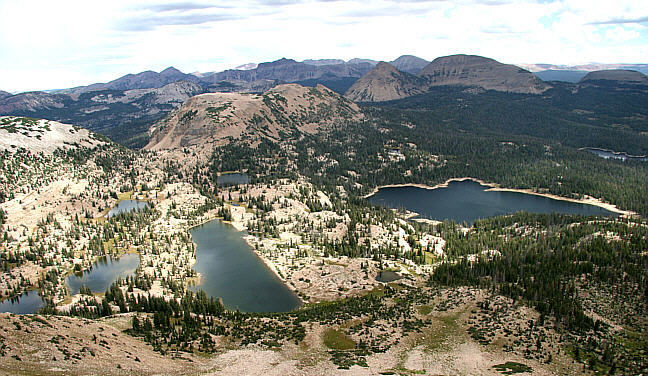
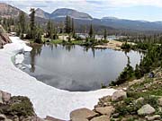
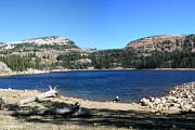
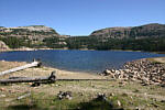
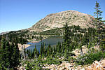
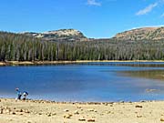
On September 6th of 2005, Dale Wing, Roy Zimmerman and I, went for a hike up in the high Uinta Mountains of eastern Utah. We set out to climb Mount Watson in the Trial Lake area. This hike started out about 10,000 feet above sea level and ended up at 11,521 feet. It's not the highest mountain in the Uintas. Many are higher than 12,000 feet and some, like King's Peak are above 13,000. We chose this one for being alone and surrounded by many lakes. Mount Watson is quite steep all around and mostly deep rock slides near the top. There is no trail, so we looked around for a slope that seemed easier to navigate. The ascent we chose was between Watson Lake and Clyde Lake, but it was still quite steep and a lot of work in the thin air. Very tiring. From the base of the mountain on up is above the tree level. Climbing over the rock slides near the top is something I don't recommend. Almost every rock stepped on moves a little. I was constantly worried about starting a rock slide. Still, getting to the top and seeing the fantastic view from there was worth all the effort. Someone built a large cairn at the top, probably to shield a fire from the winds.

you can view my photos by clicking on either picture here
or the 'View Photos' button
or the 'View Photos' button
We hiked the Clyde lake trail to where we started climbing the mountain, and on the return trip came back by way of the Notch Trail, it being a better trail and not as steep. It did add an extra mile to the return trip, but was easier walking. The GPS tracking showed that we walked 7.4 miles and climbed about 1,500 feet. Turned out to be a long day. We hiked for 9½ hours and with the driving time, the day was 14 hours long.
CLICK for GPS map of our trek

- 45 photos -
to look at these photos
click 'View Photos' button
to look at these photos
click 'View Photos' button
Related Photos
We have hiked Clyde Lake and Notch Mountain loop often,
so there are many related hike pages included here
Notch Mountain, 2013

Notch Mountain, 2011
Notch Mountain, 2010

Notch Mountain, 2009
Notch Mountain, 2000
Clyde Lake, 2004
Notch Mountain, 2014
More Uinta Hikes

My photos were taken with a Canon EOS 20D, 8.2 Megapixel SLR Camera using a 17-85mm IS wide angle to 5x zoom. Photos taken by Dale Wing were with his Canon EOS 350D, (Digital Rebel XT), 8.0 Megapixel SLR Camera also using the 17-85mm IS wide angle to 5x zoom. Roy Zimmerman contributed some of the photos using his Digital Nikon Coolpix 885, 3X Optical Zoom with 3.21 Megapixels. Some of these photos were taken with a Canon 100-400mm telephoto zoom lens. Our original photos were taken at aprox 3050 x 2000. These photos are set to 750 x 500 for faster loading. You are welcome to look at or download any of the photos. If you use them on any other webpage, please give credit and refer back to me.
[an error occurred while processing this directive]
Visitors on site now (
[an error occurred while processing this directive]
)
Total visits
[an error occurred while processing this directive]
We have hiked Clyde Lake and Notch Mountain loop often,
so there are many related hike pages included here
|
Notch Mountain, 2013
|
Notch Mountain, 2011
|
Notch Mountain, 2010
|
|
Notch Mountain, 2009
|
Notch Mountain, 2000
|
Clyde Lake, 2004
|
|
Notch Mountain, 2014
|
More Uinta Hikes
|
My photos were taken with a Canon EOS 20D, 8.2 Megapixel SLR Camera using a 17-85mm IS wide angle to 5x zoom. Photos taken by Dale Wing were with his Canon EOS 350D, (Digital Rebel XT), 8.0 Megapixel SLR Camera also using the 17-85mm IS wide angle to 5x zoom. Roy Zimmerman contributed some of the photos using his Digital Nikon Coolpix 885, 3X Optical Zoom with 3.21 Megapixels. Some of these photos were taken with a Canon 100-400mm telephoto zoom lens. Our original photos were taken at aprox 3050 x 2000. These photos are set to 750 x 500 for faster loading. You are welcome to look at or download any of the photos. If you use them on any other webpage, please give credit and refer back to me.
Total visits [an error occurred while processing this directive]