
HIKING TO ISLAND LAKE, UINTAS
September 2008 - 72 photos
and 10 extra panoramas
September 2008 - 72 photos
and 10 extra panoramas
September 13th of 2008, Bill Joy, Judy Watson, and I drove to the west end of the Uinta Mountains and started hiking from the parking lot between Trial Lake and Washington Lake. In the past I had hiked in the same area going to the north around the vicinity of Clyde Lake, Mount Watson, and Notch Mountain, but never to the west. There are many trails and lakes in the Mirror Lake region of the Uintas and we decided to take the Smith Morehouse Trail as far as Island Lake. This trail is also called 'Lakes Country Trail'. The signs that have been placed along the trail said this would be 3 miles. We discovered later reading my GPS unit that it was 4.15 miles one way to Island Lake. The area we hiked in is northwest of Haystack Mountain, or behind it as seen from the road. It was a beautiful day for a hike, almost cloudless, with the temperature never getting above 70°.
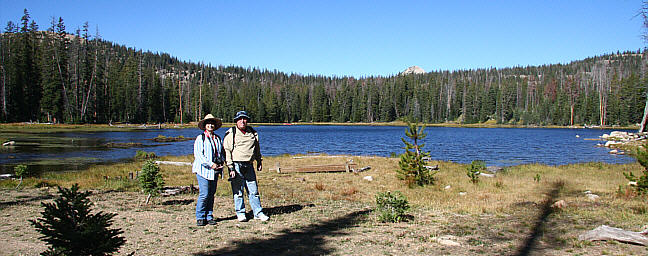
As we started out the first lake on the map was Crystal Lake, which was off the trail a ways. We walked down to it and followed along the east side then back up to the trail. From there the trail made a gentle climb over the east slopes of Haystack Mountain for about a mile, reaching 10,325 feet above sea level, then down into the valley on the other side. As we gained altitude we could see Crystal lake below and Washington lake beyond that to the south. Along the way we saw many small lakes and ponds that were not named on the map. Soon we came to a three way fork in the trail, one going down to Weir Lake, one to Long Lake, and one to Middle Fork. The Long Lake fork was the one we took for Island Lake.
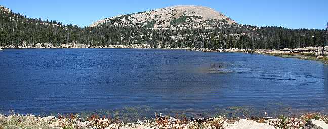
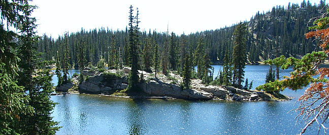
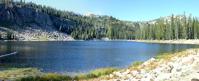
Long lake was fairly large and an island is shown on the map, but the south side was mostly a dried up area that we walked across to what could have been an island at some time. I doubt it becomes an island very often. We stopped here for lunch, then passing on around the west end of Long Lake we found a smaller lake that was quite long and very narrow. From there we climbed over a small ridge and began a decent that took us down hill to another fork at 9,925 feet, this one said Duck Lake to the left and Island Lake to the right. The climb up to Island Lake is a fairly steep trail over a high ridge to reach the lake, located at 10,135 feet. This lake does indeed have a large island with many pine trees on it.
you can view our photos by clicking on any of the pictures here
or the 'View Photos' button
or the 'View Photos' button
I stitched some photos together making long panoramas, Click here or on photo below to see them.
We were at the lake for awhile taking photos and all of us said that it was one of the best places we have hiked in to see. Later we went down to the fork leading to Duck Lake, but we were hesitant to go this way as it drops way down low, much lower than where the hike began. This would mean climbing twice the height going back. The trail to Duck Lake loops back past Pot Lake and Weir Lake returning to the original trail, so we decided to take it and see more lakes.
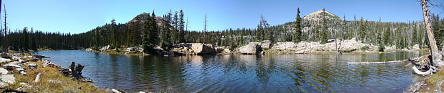
Duck Lake is at a lower altitude of 9,820 feet. We were glad that we did return this way though, even if it was longer it was not as steep or rocky and we got to see a deer as well. Also there were many small lakes not shown on the map. The trip was longer than I had calculated from the signs and map. I calculated 6.5 to 7 miles. We walked 9.85 miles total, which varied in altitued by 558 feet.
CLICK for maps of our hike

To reach the area of Trial and Washington Lakes where we started, take the Mirror Lake highway, SR 150 out of Kamas Utah and just past Provo River Falls watch for a large loop in the road. On the left side in the middle of the loop a road turns off to Trial Lake. Shortly after that the road forks right to Trial Lake. Take the left fork to Washington Lake and then the next right to reach the trail head parking. You could also take SR 150 from Evanston Wyoming coming back past Mirror Lake and over the ridge top next to Bald Mountain. The loop and turnoff to Trial Lake is just a mile below the bald Mountain ridge.
- 72 photos -
to look at these photos
click 'View Photos' button
to look at these photos
click 'View Photos' button
Related Photos
Lakes Country, 2013
Lake Lillian, 2013

More Uinta Hikes
My photos were taken with a Canon EOS 40D, 10.1 Megapixel SLR Camera and the Canon EFs 17-85mm IS wide angle to 5x zoom lens. I also used a Canon EF 70-300mm IS Telephoto for close ups. Some of these photos were taken by Bill Joy with his Fujifilm Finepix s6000fd, wide angle to 10.7x optical zoom, and others by Judy with her Canon Digital Rebel XTi, using a Canon EFs 18-55mm Wide angle to 3x and an EF 75-300mm 10x zoom lens.
These photos are set to lower resolution and compressed 10:1 for faster loading. You are welcome to look at or download any of the photos. If you use them on any other webpage, please give credit and refer back to me.
[an error occurred while processing this directive]
Visitors on site now (
[an error occurred while processing this directive]
)
Total visits
[an error occurred while processing this directive]
Lakes Country, 2013
|
Lake Lillian, 2013
|
More Uinta Hikes
|
My photos were taken with a Canon EOS 40D, 10.1 Megapixel SLR Camera and the Canon EFs 17-85mm IS wide angle to 5x zoom lens. I also used a Canon EF 70-300mm IS Telephoto for close ups. Some of these photos were taken by Bill Joy with his Fujifilm Finepix s6000fd, wide angle to 10.7x optical zoom, and others by Judy with her Canon Digital Rebel XTi, using a Canon EFs 18-55mm Wide angle to 3x and an EF 75-300mm 10x zoom lens.
These photos are set to lower resolution and compressed 10:1 for faster loading. You are welcome to look at or download any of the photos. If you use them on any other webpage, please give credit and refer back to me.
These photos are set to lower resolution and compressed 10:1 for faster loading. You are welcome to look at or download any of the photos. If you use them on any other webpage, please give credit and refer back to me.