
High Uintas Snowshoe Trip
Ruth Lake Area
May 2014
54 photos
Ruth Lake Area May 2014
54 photos
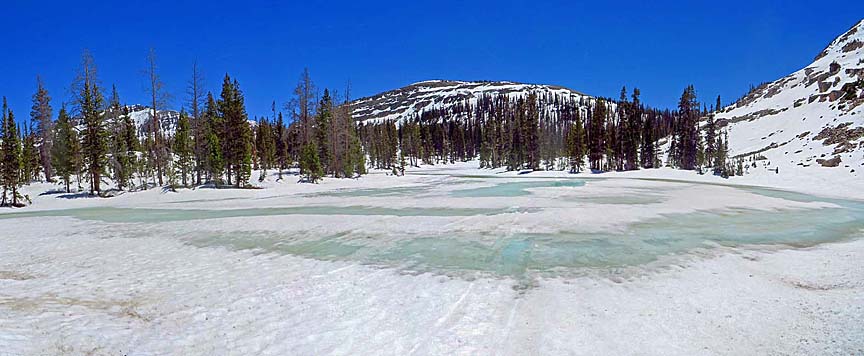
On May 26th, 2014, I went snowshoeing with Bill Joy. We did this in the Western Uintas mountains above 10,000 feet. They opened the Mirror Lake Highway earlier than I have ever seen before, and after checking it out 4 days earlier and seeing there was still some snow up high, I decided to do it. Just about everyone else that I had asked to go, couldn't for one reason or another, but Bill was still willing to try it, so we did.
We decided on hiking up to Ruth Lake and some of the other small lakes in the area because it was higher than most of the other places, and still had plenty of snow. It was everything I had hoped for. The best snowshoeing I have done yet. The day was beautiful, not a breeze, deep blue skies, and the temperature was just perfect for hiking with short sleeves. The snow varied from 4 feet deep down to about 2 feet. We did see a few bare spots, but not often. In some places we could see the stream running fast, but most of the stream was still under the snow. We could hear it under us as we walked over snow bridges. I was really worried that we might fall in, but it only happened once. We crossed the stream many times.
The snow surface was pretty firm, but not down deeper. The biggest problem was rocks and boulders. If they were close to the surface, they would pick up heat and radiate it out into the snow. If you stepped there, you went through. Bill and I both did it from time to time, but we still had fun and enjoyed the day.
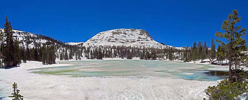
The snow up there is melting very fast. It had melted a lot in the last 4 days. While we were hiking it melted so much that we couldn't find our own tracks when coming back down. I only found a slight mark of where we had come up, and that was in the shade.
We didn't do a very long hike, only 3.4 miles, but snowshoeing is harder than regular hiking and at that higher altitude we got tired quickly. Still we managed to trek past 8 small lakes, some of them twice. We started out at 10,136 feet above sea level and climbed about 300 feet higher.
We didn't do a very long hike, only 3.4 miles, but snowshoeing is harder than regular hiking and at that higher altitude we got tired quickly. Still we managed to trek past 8 small lakes, some of them twice. We started out at 10,136 feet above sea level and climbed about 300 feet higher.

I knew that people took snowmobiles up there in the winter, but didn't realize how much they did it. There must be thousands of them. There were tracks on every square foot of snow that they could find to ride on. The tracks criss-cross every one of the lakes we hiked to, and went right up the steep mountainsides.
you can view all the photos by clicking on any of the pictures here
or the 'View Photos' button
or the 'View Photos' button
CLICK for map of our trek

- 54 photos -
to look at these photos
click 'View Photos' button
Related Photos
More Snow Shoeing

My photos were taken with a small Canon Powershot, SX280, a 12 Megapixel Camera which has Image Stabilazation and a lens going from wide angle to 20x optical zoom.
These photos are set to lower resolution and compressed 10:1 for faster loading. You are welcome to look at or download any of the photos. If you use them on any other webpage, please give credit and refer back to me.
[an error occurred while processing this directive]
Visitors on site now (
[an error occurred while processing this directive]
)
Total visits
[an error occurred while processing this directive]
to look at these photos
click 'View Photos' button
|
More Snow Shoeing
|
My photos were taken with a small Canon Powershot, SX280, a 12 Megapixel Camera which has Image Stabilazation and a lens going from wide angle to 20x optical zoom.
These photos are set to lower resolution and compressed 10:1 for faster loading. You are welcome to look at or download any of the photos. If you use them on any other webpage, please give credit and refer back to me.
These photos are set to lower resolution and compressed 10:1 for faster loading. You are welcome to look at or download any of the photos. If you use them on any other webpage, please give credit and refer back to me.