
WATERFALL CANYON
Malan's Waterfall
June 2011 - 36 photos
Malan's Waterfall
June 2011 - 36 photos
Friday, the 10th of June, 2011, We hiked up to Malan's Falls in Waterfall Canyon. I invited quite a few people to go this time, but only 5 showed up. Besides me, my daughter Cheryl, Bill, Don, and Larry did the hike.
This was a fairly short hike, but quite steep. The hike is 3.2 miles round trip, climbing just over 1,000 feet. The higher you go in Waterfall Canyon the steeper it gets, until it's quite steep. And it can also be a wet hike, especially if you fall in the creek like I did. I was trying to jump across at one point for some photos, and didn't quite make it.
Just below the falls on the left side, you have to cross the creek again and there is no bridge, but this year there were some saplings put across the creek with flat rocks laid on top. Not the best bridge I have seen, but it worked. All of our group crossed without a problem, but we saw one lady that said she fell from there into the creek. She was totally wet, head to toe.
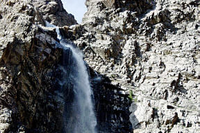
Up at the waterfall there was a lot of spray coming off the falls, and it was cold and wet. These falls are about 200 feet high, and this early in the year there was a lot of water coming down. The falling cold water cools the air, causing a down draft that blows pretty hard, stirring up a lot of wet spray. Because I was already wet, I walked through the creek at the base of the falls for more pictures. That spray soaked me totally.
We made pretty good time on this hike, about an hour and a half going up, less than an hour coming down. I took 85 pictures this time, but will only post 36, and some of those are Bill's.
This was a fairly short hike, but quite steep. The hike is 3.2 miles round trip, climbing just over 1,000 feet. The higher you go in Waterfall Canyon the steeper it gets, until it's quite steep. And it can also be a wet hike, especially if you fall in the creek like I did. I was trying to jump across at one point for some photos, and didn't quite make it.
Just below the falls on the left side, you have to cross the creek again and there is no bridge, but this year there were some saplings put across the creek with flat rocks laid on top. Not the best bridge I have seen, but it worked. All of our group crossed without a problem, but we saw one lady that said she fell from there into the creek. She was totally wet, head to toe.
Up at the waterfall there was a lot of spray coming off the falls, and it was cold and wet. These falls are about 200 feet high, and this early in the year there was a lot of water coming down. The falling cold water cools the air, causing a down draft that blows pretty hard, stirring up a lot of wet spray. Because I was already wet, I walked through the creek at the base of the falls for more pictures. That spray soaked me totally.
We made pretty good time on this hike, about an hour and a half going up, less than an hour coming down. I took 85 pictures this time, but will only post 36, and some of those are Bill's.
Malan's Falls 2011

New Info: Chris Peterson bought the property of Malan's Basin from the Malan family, and recently obtained all the property below including Waterfall Canyon. He is fencing the area and has put in gates. He now has rangers patrolling his property and they may require you to show ID and sign a log book to hike in the area. Todd Black, executive director of the Utah Cooperative Wildlife Management Association, said Peterson is within his legal right to use his own private rangers to enforce the laws of his land.
CLICK to see trail map up to the waterfall

To get to the Trailhead, drive to the top of 29th street in Ogden, Utah. 29th does not go through at Ogden High School on Harrison Blvd, so you have to go up either 28th or 30th, then back over to 29th St. At the top of 29th turn right into the trailhead parking lot. Take the trail that goes east towards the mountain, and when you reach the flat north south trail, take the trail south. The trail sign post there isn't very clear on this. When going into Waterfall Canyon you come to a bridge over the creek, the trail going ahead there is part of the Bonneville Shoreline Trail, so you want to turn left after crossing the bridge and continue on up the canyon. There is another bridge farther up and most cross over going on up the left side of the canyon. You can get through on the right side, but there is more brush to contend with. There are camp sights along that side though.
you can view our photos by clicking on this picture
or the 'View Photos' button
- 36 photos -
to look at these photos
click 'View Photos' button
Related Photos
Other hikes to Malan's Waterfall
Malan's Waterfall, 2002
Malan's Waterfall, 2005

My photos were taken with a Canon Powershot, SX210, 14 Megapixel Camera which has Image Stabilazation and optical lens from wide angle to 14x zoom. Some of these photos were taken by Bill Joy with his Olympus E620 SLR and additional lenses.
These photos are set to lower resolution and compressed 10:1 for faster loading. You are welcome to look at or download any of the photos. If you use them on any other webpage, please give credit and refer back to me.
[an error occurred while processing this directive]
Visitors on site now (
[an error occurred while processing this directive]
)
Total visits
[an error occurred while processing this directive]
To get to the Trailhead, drive to the top of 29th street in Ogden, Utah. 29th does not go through at Ogden High School on Harrison Blvd, so you have to go up either 28th or 30th, then back over to 29th St. At the top of 29th turn right into the trailhead parking lot. Take the trail that goes east towards the mountain, and when you reach the flat north south trail, take the trail south. The trail sign post there isn't very clear on this. When going into Waterfall Canyon you come to a bridge over the creek, the trail going ahead there is part of the Bonneville Shoreline Trail, so you want to turn left after crossing the bridge and continue on up the canyon. There is another bridge farther up and most cross over going on up the left side of the canyon. You can get through on the right side, but there is more brush to contend with. There are camp sights along that side though.
or the 'View Photos' button
to look at these photos
click 'View Photos' button
Related Photos
Other hikes to Malan's Waterfall
Malan's Waterfall, 2002
Malan's Waterfall, 2005
My photos were taken with a Canon Powershot, SX210, 14 Megapixel Camera which has Image Stabilazation and optical lens from wide angle to 14x zoom. Some of these photos were taken by Bill Joy with his Olympus E620 SLR and additional lenses.
These photos are set to lower resolution and compressed 10:1 for faster loading. You are welcome to look at or download any of the photos. If you use them on any other webpage, please give credit and refer back to me.
[an error occurred while processing this directive]
Visitors on site now (
[an error occurred while processing this directive]
)
Total visits
[an error occurred while processing this directive]
Other hikes to Malan's Waterfall
|
Malan's Waterfall, 2002
|
Malan's Waterfall, 2005
|
My photos were taken with a Canon Powershot, SX210, 14 Megapixel Camera which has Image Stabilazation and optical lens from wide angle to 14x zoom. Some of these photos were taken by Bill Joy with his Olympus E620 SLR and additional lenses.
These photos are set to lower resolution and compressed 10:1 for faster loading. You are welcome to look at or download any of the photos. If you use them on any other webpage, please give credit and refer back to me.
These photos are set to lower resolution and compressed 10:1 for faster loading. You are welcome to look at or download any of the photos. If you use them on any other webpage, please give credit and refer back to me.